We use cookies to ensure you get the best experience on our website.


Get a consultation
Just type your contacts
By clicking the button, you consent to the processing of personal data and agree to the Privacy Policy
GEOANALYTICS for BUSINESS
The SmartLoc system can be used to solve many highly specialized tasks: from advertising placement to the location of warehouse premises
DEVELOPMENT & REAL ESTATE
Parameter evaluation
Detailed analysis of the environment: audience and profile composition of commercial infrastructure for optimal development of territories, competitive analysis

PHARMACEUTICS & MEDICAL SERVICES
Local Audience Analysis
Assess the volume, structure and other indicators of the local audience of objects to form the optimal range of goods and format of services

RESTAURANT BUSINESS
Traffic near the location
Find out how many people pass by the location you are interested in and the competitors' locations every day. Now you can choose the most popular places

ONLINE AND OFFLINE RETAIL
Location Analysis
Choose the best locations for your facilities and predict their success with the help of big data and artificial intelligence in the SmatLoc system

SmartLoc System FUNCTIONALITY
The user has access to all necessary geomarketing analysis data
-
Working with geodata
- Clear visualization of a large thematic data set
- Uploading and editing client data
- Various sections of information: maps, tables, summary statistics on the territory
-
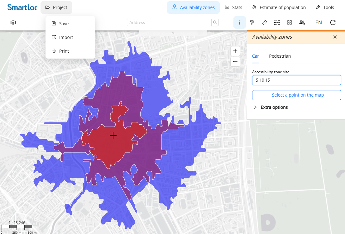
Analysis of service areas
- Research of any cities and territories
- Determining the boundaries of transport and pedestrian accessibility
- Selection of workload mode taking into account different times of day
-
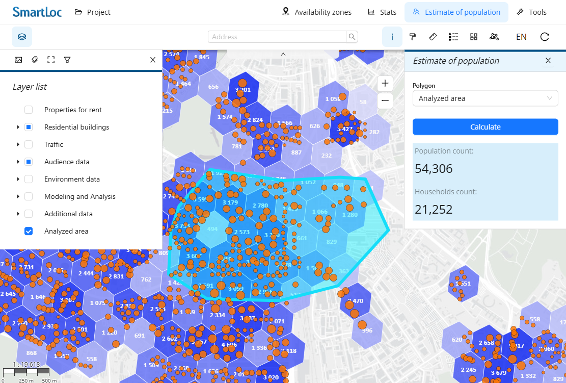
Assessing audience parameters
- Determining the population size of a random area
- Differentiation by income level
- Data on new buildings to assess audience growth potential
-
Monitoring the competitive environment
- Visualization of the location of competitors' facilities
- Determining competitor service areas
- Calculation of the saturation level of the local market
-
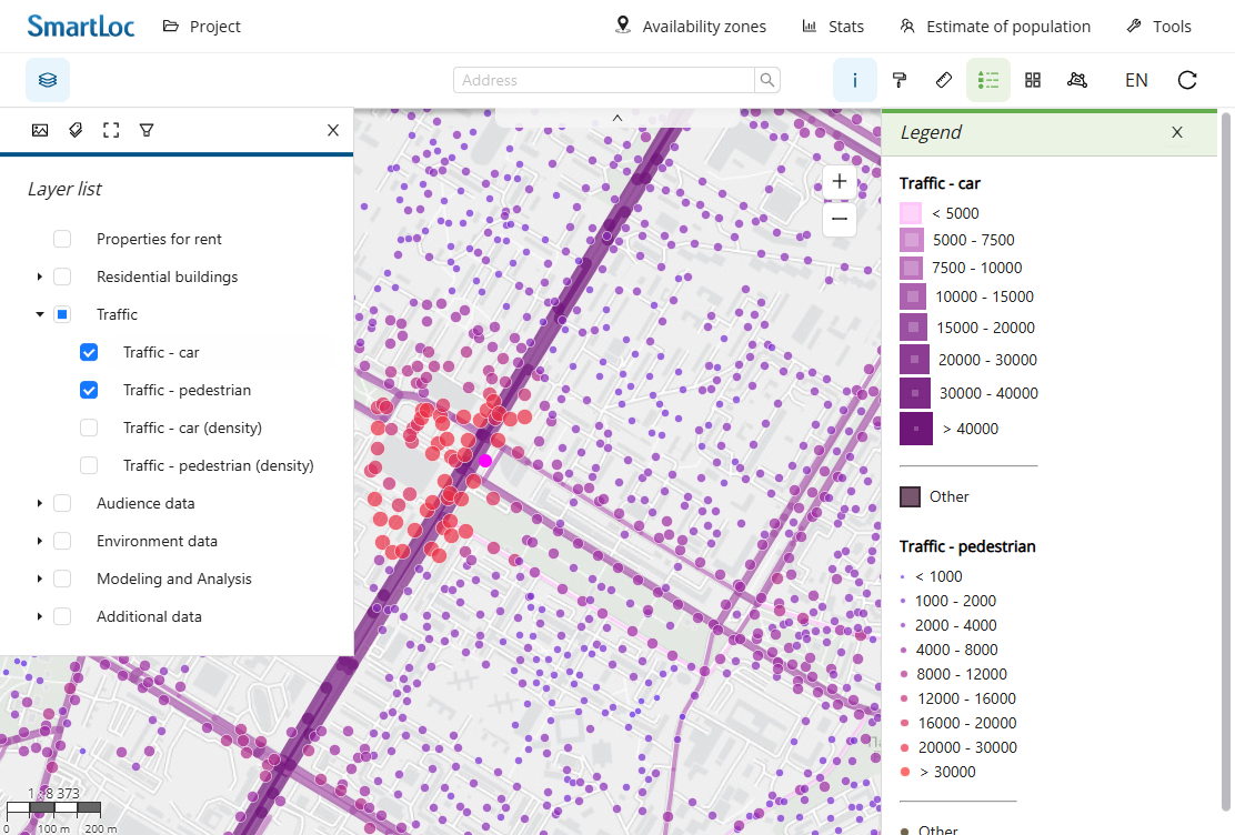
Traffic allocation
- Detailed pedestrian and car traffic data
- Multiple levels of detail for different depths of analysis
- Visualization of the placement of traffic generator objects
-
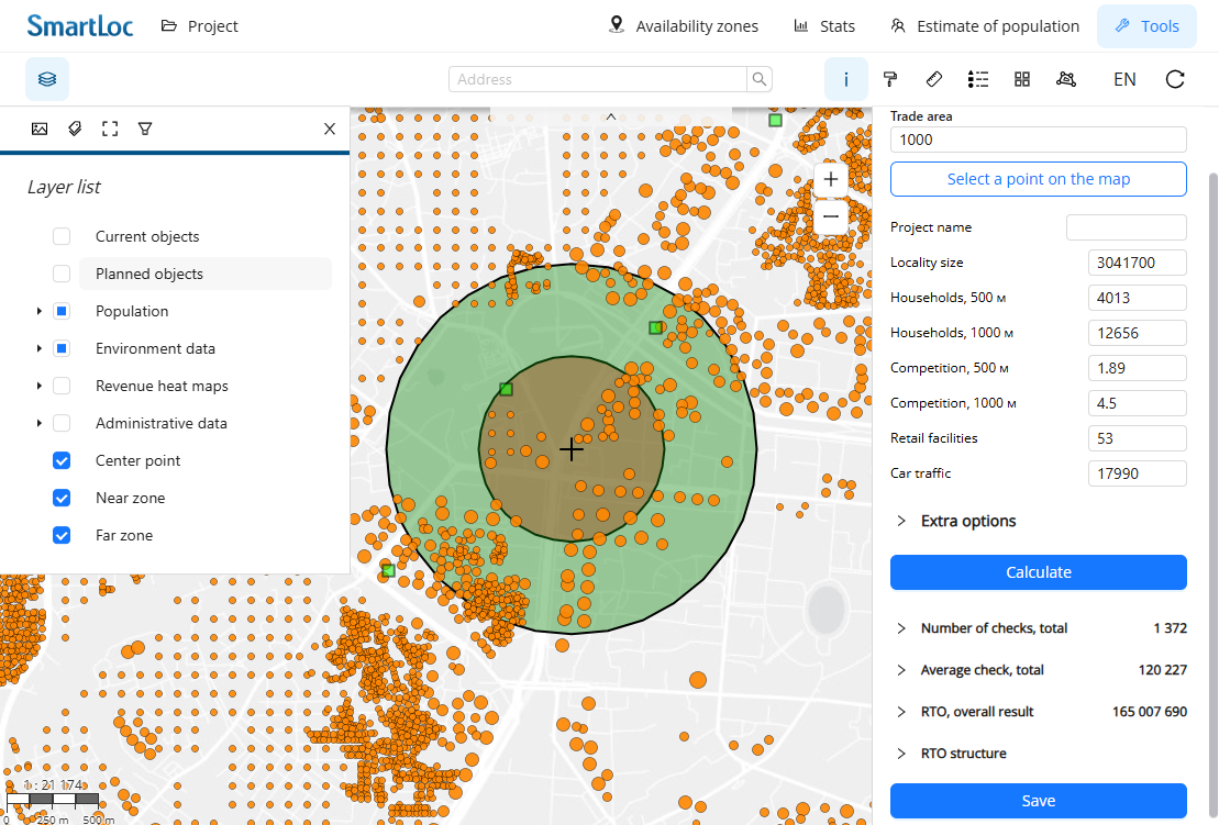
Huff Model
- Determining the penetration level and volume of the potential audience
- Finding areas with high potential to attract additional audiences
- The answer to the question “Where can we expect clients?”
-
Real estate rental and sale offers
- Monitoring the latest offers
- Enrichment of offers with geographical factors
- Rapid assessment of new premises
-
Revenue forecasting
- Turnover forecast model for a specific network
- Analysis of the maximum number of factors
- Using Machine Learning Algorithms
ADVANCED GEOANALYTICS TOOLS
SmartLoc System user gets access to additional analysis tools
Loading and visualization of client data, flexible customization of design and display methods
Data visualization


Creating Heat Maps
Built-in tool for generating heat maps based on internal and user data
Ability to work with tabular data, including filtering and summary statistics
Working with tables


Saving analysis results
Maps export, maintenance of the location database, saving of the created project and layers

Edit option
Editing data: geometry, design, attributes, creating temporary layers
Selection by layer, boundaries of spatial and attribute selections
Interactive work with the map

FAQ
The minimum period for which you can access the system is 1 month
The SmartLoc geomarketing system can be connected to the following countries: Russia, Azerbaijan, Belarus, Kazakhstan, Uzbekistan. The ability to connect access to data to other countries can be specified upon request.
The service offers current offers from the most popular aggregators. Operational analysis of new premises will provide you with a key advantage - speed of decision-making. Additionally, you can study the dynamics of the supply market and select the most relevant premises in the areas of interest
One of the important geomarketing models. Allows you to determine the coverage area, calculate the audience size and the level of penetration (catchment area with penetration), taking into account the location of the population, the influence of competitors and the characteristics of the road network. Allows you to identify areas with high potential for attracting target audiences
Development and integration of a turnover forecast model for a specific network. Analysis of the maximum number of spatial and local factors and identification of the most important ones affecting trade turnover. Increasing accuracy through deep spatial analysis methods and machine learning algorithms. Accelerate and standardize the location analysis process. Reducing uncertainty when making decisions on network development